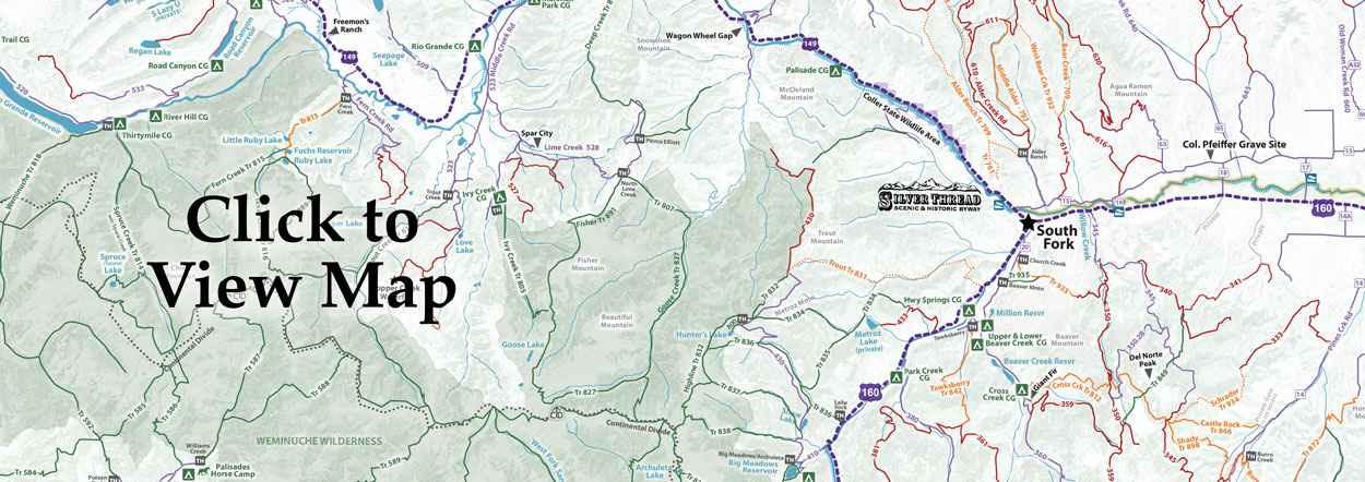
The Rio Grande National Forest is filled with riding opportunities for beginner and advanced riders. Several trails are within a couple miles drive from town, and some are specifically listed as multi-use for bikes…not to mention the hundreds of miles of forest service access roads open to cyclists of all abilities. Many trails are multi use - so be prepared for hikers, horses, and ATV’s along the way.
Know Before You Go
- Tell Someone: Where you’re going When you’ll be back
- Check the Weather; and then wear ALL the layers anyway
- Altitude WILL effect you! You are at 8,000ft+ elevation - we have more beauty, but less oxygen!
- Maps - don’t rely on cell service. Either have them printed or downloaded.
- Stick to the trails; Leave any gates the way you find them!
- Uphill has the right-of-way. Bikers yield to hikers, all yield to horses.
- Buy a Search & Rescue Card ($3 online). The card helps reimburse local SAR team’s expenses for search and rescue missions
Rio Grande Bicycle Service offers Bike Rentals and Shuttle Service
Our Favorite Mountain Bike Trails
Deep Creek #806 (F3-4)
LOWER: 4 miles, 2-3 hrs • Easy
This portion of the trail is a smooth sweeping single-track. UPPER: 7 miles, 4-5 hrs • Moderate There are a few water crossings, and a few rocky sections.
TOP: 9 miles, 2-3 hrs • Expert
8750-11,400ft • A great challenge to clean the entire upper section.
Middle Frisco Creek #879 (J6)
LOWER: 4 miles, 2-3 hrs • Easy
Start out riding lower section. This portion of the trail is fairly smooth.
UPPER: 7 miles, 3-5 hrs • Moderate
9500-12,000ft • Expect to avoid a few stationary rocks and tree roots and work on switchback skills!
Penitente Canyon (K3)
A LOOP • 2.75 miles • Moderate
A loop will start out with a short grunt of a climb, and then it levels out on the ridge where it is fast and fun. For expert riders, there are plenty of challenging "Rock options" along the way.
B LOOP: 2.75 miles • Easy
B loop is a good place to learn the basics of mtn. Biking on single-track. The trail is mostly smooth with a few minor rocky spots. Also good for Intermediate riders to focus on form and speed.
Treasure Mountain #565 (G7-8)
28.5 miles, 4-7 hrs • Moderate, Expert
This trail will test your abilities for downhill biking! Occasional dismounts over creek crossings.
Trout Creek #831 (G-H5)
4 miles to the creek • Moderate, Expert
This is a fun trail but be careful of exposed areas - don't fall off the trail. For expert riders, the trail is fast and great for race training.
Palisade #761/Alder Bench #799 (H4-5)
7 miles, 2-4hrs • Expert
Expect some rock gardens, and even a few spots with some loose rock.
Lake Fork #836 (G6)
7 miles, 4-7hrs • Expert
This trail is comprised entirely of expert level high alpine single-track. The trail crosses rock slides & climbs to high alpine meadows giving you some of the most amazing mountain views.


